

Pilot in Ohio spends 6 hours 'drawing' map of US using flight path to celebrate country's 250th anniversary
A pilot's patriotic "drawing".
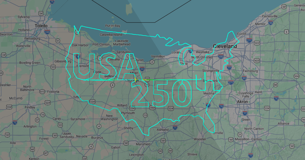
PHOTO: Screengrab/FlightRadar24
 PUBLISHED ONJuly 04, 2026 6:00 AMBYDrima Chakraborty
Americans are celebrating the 250th anniversary of the US gaining independence on Saturday (July 4), and one person had a particularly creative way of commemorating the occasion.
A pilot spent six hours in the air over the state of Ohio to 'draw' a map of the contiguous part of the country and write out "USA 250th" using their flight path.
Taking off on July 3 at around 6am EDT (6pm SGT) from Norwalk Huron County Airport, the feat was achieved using a Cessna Skylane RG with the registration N4936T and attracted the attention of several aviation enthusiasts.
FlightRadar24 even sent out a push notification to users who have the featured flights alert set up at around 10.17pm SGT.

According to AirLive, it was particularly impressive as the small fixed-wing, single-engine aircraft can only hold 85 gallons of usable fuel, and considering it uses 11 to 14 gallons per hour, would have been pushed to its operational and legal limits to complete the flight.
A check on Cessna's website shows the aircraft's maximum range to be 915 nautical miles with a top speed of 145ktas (knots true airspeed), which also confirms the aircraft to have just over six hours of total flight time fully fuelled — cutting it close.
According to the flight path on FlightRadar24, the pilot first 'drew' the "USA", then the "250th" before finishing with the complex map, reaching a maximum barometric altitude of 9,850ft and landing back in Norwalk Huron County Airport six hours and eleven minutes after taking off.
This isn't the first time pilots have showed off their artistic chops using flight paths.
Back in December 2025, Ohio-based pilot Tim Pearson took to the skies twice to celebrate Christmas.
On Dec 15, he 'drew' a Nativity scene using over five hours, before taking three hours to 'draw' the Grinch on Dec 21.
[[nid:727260]]